 The best case is to have a map and a compass. If you have a general idea of the terrain you can navigate without either, of course. But if you have to choose one or the other, unless the map is complete crap, choose the map.
Why not choose a GPS? A GPS depends on things that you cannot control, including satellites (vulnerable to interception and destruction in wartime, and failure in peacetime) and the electromagnetic spectrum (vulnerable to jamming, meaconing, EMP and other QRM — manmade interference — and sunspots, areas of bad radio propagation (like iron-rich geological formations), and other QRN — natural interference.
Jamming GPS signals is child’s play, because (1) the frequencies used are fixed and published, and (2) a satellite is sending a very low-power signal from very far away.
A GPS also depends on something that has a knack for letting a guy down: batteries. GPS navigators and other smart devices are an update of the old pilot’s joke about a flashlight: something you put in your bag to hold dead batteries. (There are circumstances in which this joke is the very living soul of not funny).
What’s a Topographical Map?
A map is a graphic description of a physical place in (usually) plan view, meaning from an imaginary viewpoint overhead. There are innumerable kinds of maps. Planimetric maps are drawn to scale (of which more in a moment), show borders and boundaries, (usually) cultural features like roads, and coast- or water-lines. If you own a house or land, you have probably seen your lot on a planimetric map. A Mapquest street map page is a planimetric map (it’s also a thematic map, which is a kind of map that has a theme, naturally. Thematic maps can be planimetric, but don’t have to be).
A topographical map is a type of planimetric map that also shows the height of the terrain. How do you show the Z axis of the real world on a two-dimensional map? The convention for depicting height on modern topographic maps is to use isometric lines. That scary foreign word just means “same distance,” iso metric, see? So each height-depicting line on the map represents the same vertical distance as the others. This has some useful applications in the real world, which is where we want to use our maps, right?
It is the isometric lines or contour lines (so called because each line follows the contour of the land at a given height relative to mean sea level) that set a topo map (as we call them to save keystrokes) apart from other kinds of maps.
Unless you have occasion to work with very old maps, military topographic maps will be calculated in SI units, with isometric lines a fixed distance apart in meters and marked elevations (of benchmarks, hilltops and other significant Z Axis features) in meters as well, and distances and a scale in kilometers. In the US, topo maps made for civilian use will have these items marked in Imperial units — feet and miles.
Globally, topographical maps are very similar. Anyone who has used a British Ordnance Survey Map, USGS Map, or NATO military map can pretty much make the translation to the others no problem. Even a Russian or Chinese map is very useful (the Russians have always made superior maps). Even if you can’t read the language you can still see the terrain. The various grid systems used are not always interoperable, though. (We’ll get to that).
What’s On A Topographical Map?
There are essentially three things: the geological features, which include the basic shape of the terrain, things like hills, rivers, coastlines, and slopes; the cultural features, which are the things that grow on the terrain or that people build on it, like forests, villages, roads and railroads; and navigational and informational features, including various things that let you use the map.
Geological Features
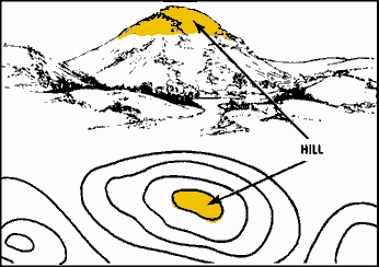 A map can give you a good handle on terrain features, if you read the contour lines. This bit of instruction uses the topography of human hands to walk you through the most common terrain features. There’s a lot more the lines can tell you, and you pick it up instinctively sooner or later. For example, on any given map, since contour lines come only at one interval, the closer together the lines on the map, the steeper the terrain. You will notice that watercourses are always in the low point, and that contour lines form a V across the watercourse, with the narrow end of the V pointing uphill and upstream. Bodies of water and watercourses are geological features, and they are always depicted in blue.
This web page recycles government training materials meant to train soldiers to understand the association between the contour lines on their maps, and the terrain on the ground. It shows the basic terrain features; the hill above is one of them. (The page may have an annoying popup. Just dismiss it).
Cultural Features
Cultural features include vegetation, usually shown as green, and anything humans built on the land, including roads, bridges, trails, railroads, power lines, structures, cities, etc. As a rule of thumb, geological features are more stable and useful for navigation that cultural ones. Barring Air Force intervention, a hilltop’s height isn’t going to change. The shape of roads and borders of towns change all the time.
Navigational and Informational Features
There are many of these, including the Legend, which describes the sorts of features you might see on the map; the declination diagram, which we’ll deal with in the next installment; the indicator of north (part of the d.d.) which is rather important; and information about the datum used (this is the mathematical description of the shape of the Earth that undergirds the navigational features) and the grid system. This is where we run into differences by nation and even by purpose of the map and its recency. Datums are occasionally updated and this means grids aren’t interoperable (some US maps still used the North American Datum of 1927 (NAD27) during our service, and other maps used WGS83 or another datum — a hazardous combination when you’re slinging lead and steel around). The Russians and their allies, for example, use a different grid system (Gauss-Krasovskiy) than NATO and their allies (MGRS, which is a superset of the Universal Transverse Mercator system). This gets interesting when you have lots of nationalities interoperating in one battlespace, but for most of you, the way to deal with this is:
- Check that everybody’s map has the same Datum and grid system.
- If not, get help! Your friendly SF intel sergeant can probably do MGRS to GK grid conversions, and your weapons guy can deal with artillery tuned with different numbers of mils in a circle.
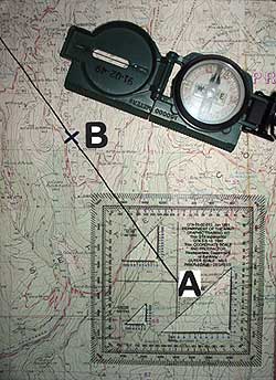
 Maps have grids that are set up for a military-type grid reference system, which should let you plot a point quite accurately, or alternately for latitude and longitude, depending on their intended use. Lat/Longs are hard to use in an on-foot situation, because in most of the world parallels and meridians don’t intersect quite squarely. The good news is, that even a map only gridded with lat/longs usually has ticks you can use to set up a UTM grid.
Grids are always read right and up. In map terminology, that’s easting and northing. How and why the grids are set up is part of every military map reading class, but do you know what? You don’t need to know it, any more than you need to know how a torque converter works to drive a car. Yes, it’s great to have knowledge in depth, but right now, you need knowledge you can use.
Some Homework if you want it:
Reading Topographic Maps, by the OK Geological Survey.
Reading-Topographic-Maps-Oklahoma-Geological-Survey.pdf

Kevin was a former Special Forces weapons man (MOS 18B, before the 18 series, 11B with Skill Qualification Indicator of S). His focus was on weapons: their history, effects and employment. He started WeaponsMan.com in 2011 and operated it until he passed away in 2017. His work is being preserved here at the request of his family.
23 thoughts on “Learning Land Navigation: Second in a Series: The Topographic Map”
I just wanted to say “thanks” for this post and the others in the series. Great info and I’m going take my compass and map and do some work this weekend.
I can attest to the need for a paper map as a backup at least to GPS. A recent trip to Iceland found us with a car rental GPS that decided it was going to give us random directions for streets that weren’t there. (didn’t realize it was out of whack until we were well north of the airport, and were too jetlagged to want to go back). We stumbled our way to our lodging with a brochure map, and purchased a fairly good paper map at a gas station the next day which served us marvelously for the remainder of the trip.
No map can make remembering Icelandic names and words easier, though.
MapQuest? Is that still a thing?
-John M.
did someone say “topo map”?
/white smoke
“Beaver Valley” 🙂
by the by, if i had a dollar for every person who started with the numbers on the left, then the numbers on the bottom, thereby reversing the “read right, then up” dictum, i’d have been with a lot fewer idiots who were LLMF.
step one to using a mil-spec topo map: RTFM! all the directions are clearly printed on it.
of course, you have to be able to read for comprehension, so there’s that as a barrier to success.
(text begins to scroll from the bottom of the screen to the top)
A Long, Long Time Ago in a Swamp the size of a Galaxy Far, Far Away…
It is a time of great uncertainty and stress for a yet unpinned Teamguy
Flush from his heady situational victory and escape from BUD/S
He finds there are more frightening things in the Galactic Surf Zone than First Phase Instructors
He has encountered beings known as LAND WARFARE CADRE
Initially pleased with the revelation that he was to be a POINTMAN
This sense of awesomeness was soon to be brutally removed in nonsurgical fashion…
(end scrolling text)
“Lesson one dude. You’re leading a pack of supremely self confident badasses. UNDER NO CIRCUMSTANCES should you ever let on that you are lost, or even less than 100% certain of your exact position. The second any one of them gets an opening to ‘help’ you you are going to have the whole fucking platoon attempting to navigate and most of them will not have 1 platoon’s experience under their belt as a pointguy. I don’t care who says what or what is actually going on in your fucked up head for the next few weeks, you are by default on top of it and you know exactly where you are at all times. Got it?”
Hours…maybe days behind schedule in an endless swamp with amazingly shitty weather to limit visibility to the point that spotting terrain in the distance was not an option, a hopelessly lost (you didn’t hear it from him) aspiring Amphibious Killer Assassin Pointguy once again signals a halt, and with feigned salty confidence…at least *looks* like a dialed-in pointguy. Hopefully.
At this point, a dreaded member of the LW Cadre joins the 1-dude conference beneath temporary light discipline cover (3 is definitely a crowd) and inquires as to the reality of the situation. Probably because the guys need to actually directed to the actual place where they are going to ambush the fuck out of someone, and the ambushees/cadre/observers are probably almost out of beer.
Sith Cadre: “You don’t have a fucking clue where we are, do you?”
Aspiring Sith Pointguy (in properly instructed character): “I’ve got our position just fine. I came one ridge too far South before I (more professional sounding, delivered in a competent sounding manner bullshit)…”
Sith Cadre: “Dickhead, you wouldn’t notice a proper topo reference if your girlfriend shoved it up your ass. What ridge would that be? We’re in a fucking swamp.”
Nerd confession: said anonymous former newguy pointguy more than once tried to draw on the image of a Steely Eyed Ranger, stalking across the Dead Marshes, Alone, and Completely Aware of his Exact Location at All Times.
Good times…’according to a friend of mine’. 😉
Back in the days when frogmans were amphibulous creatures, I can see lack of a terrain reference being an issue. You’ve got to come inland from the “maritime nexus” for terrain to start being really obvious, unless you’ve got cliffsides (like Grenada) or a prominent cultural feature… like an airfield… ’nuff said about that, it was a black day for the US and for your guys.
I should probably have said something about the rarity, but reality, of errors on maps. Come to think of it, didn’t one of our subs prove rather kinetically — maybe twenty years ago? — that NGA/NIMA/DMA whatever they were calling back then didn’t necessarily plot every seamount in the right place? They were motoring through the deep blue Pacific without a care in the world (well, nuke sub, so in a state of neurotic hypervigilance) when WHARANGO! They hit Mother Earth at a classified number of knots, breaking the boat in fortunately non-sinking ways, and breaking a whole bunch of the inhabitants as they kept moving at a classified number of knots when USS Boat stopped short. Until they lit upon the structure and fittings of said boat.
Must have been a bit frightening, that.
USS San Francisco 2005
article in nick
Figures. The Navy keelhauled the CO, and did nothing about the outfit producing the bad charts.
http://www.sfgate.com/news/article/Vets-applaud-skipper-of-nuclear-submarine-in-2666943.php
Some admiral’s nephew must have been up for a command slot or something.
if you read through all the way to the bottom, the CO was lax, and so was the nav team. (there were other charts on board that would have given warning of the issue, but they were not consulted. the one they used was the only one w/o said warnings, for one thing, and the fathometer was reading 1000+ feet or more shallower than what the charts said)
however, the Squadron and Group were aware of the issues, and they did nothing about them either.
lots of blame to go around
Sharkman, please tell me you don’t have a blog. I’d absolutely have to add it to those that I read regularly, & it takes long enough to make my way through them all now.
As always, great info…
LandNav is such an important skill/art actually in this day of electronic wizardry…
So grateful for the training i received back in the day, that i still use to this day while out stalking Trout waaaay out in WNC….
For folks who have not gotten military training, or do much civie stuff, REI has courses available, pretty good ones too, given the fact that you most likely will not be calling in arty or air strikes, but simply need to get from points A thru Z, with stops along along the way.
Check em out here: https://www.rei.com/events/
Where could a guy find good maps for cheap?
how about free, except for your cost of printing?
see link in nick
as discussed here
see nick
additional tips here
nick
(these were shared here previously on another thread, but i still had the tabs open for personal reference)
As covered here previously, thanks to the AMC.
https://weaponsman.com/?p=26568
It’s worth the trouble of navigating USGS’s brain-dead computer interface.
That’ll work yo.
Tks for the link.
So I freely admit to being an idiot sometimes, but where do you recommend printing? and in what form (i.e. paper type, size) specifically? I just paid $30 at Fedex for a 7.5 minute map… ooops, should’ve asked the price before sending, lesson learned, I hope. On the other hand, I have a really nice looking topo map on good quality paper now.
Post military, I got a degree in Geography. This, “How to read a map”, was literally a college class. It was an “advanced” level course. It was one of easiest classes I have ever took, the other vets int he class any I were laughing throughout the whole thing because it was so easy. It was just a semester of landnav and theory in a classroom.